Local Type 3 organization to assume command of the Black Fire
June 27, 2022 Daily Update
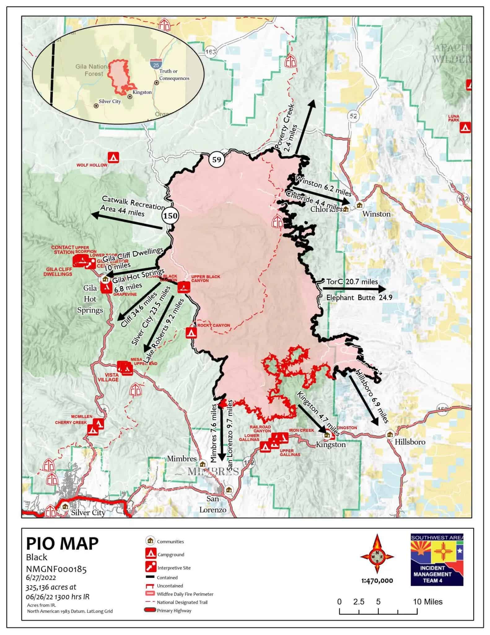
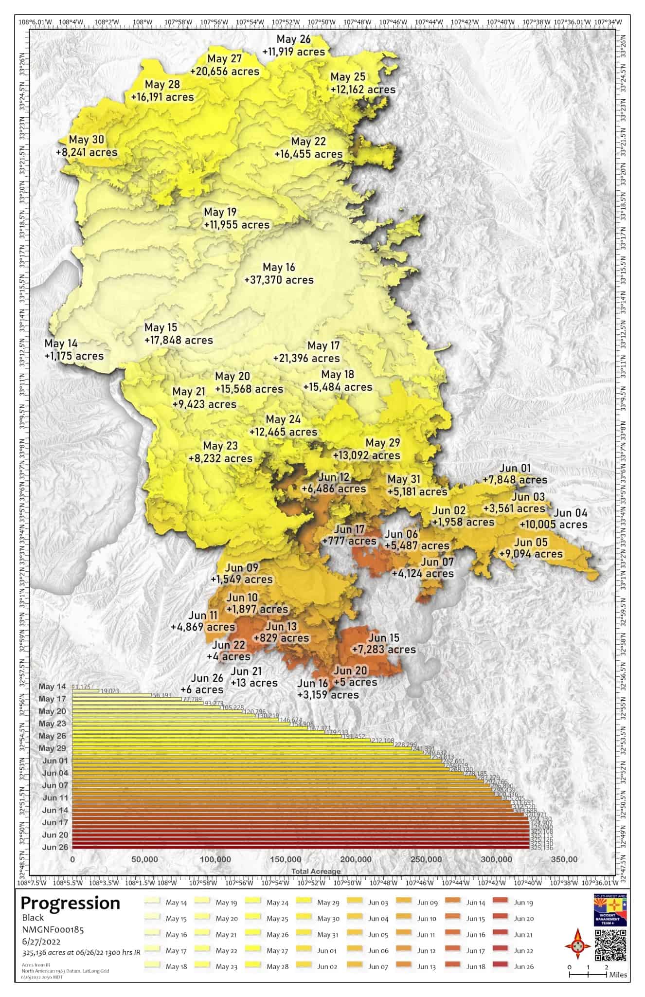
Acres: 325,136 acres
Containment: 70%
Total Personnel: 180
Cause: Human-caused, under investigation
Start Date: Friday, May 13, 2022
Location: 31 miles NW of Truth or Consequences, NM
Fuels: Timber and tall grass
Highlights: At 6:00 PM on Monday, June 27, the Southwest Area Type 2 Incident Management Team 4 will transfer command of the Black Fire to a local Type 3 organization, led by Incident Commander Joe Sampson. Team 4 extends its sincere thanks to the local communities for their support, gratitude, and hospitality throughout this incident. Due to successful firefighting efforts, the Black Fire is now 70% contained, and resources are either demobilizing to return to their home units or reassigning to assist other wildfires across the country. This is the final update for the Black Fire unless significant events occur.
Future Fire Information: The Black Fire Information phone number and email address will no longer be active after 6:00 PM this evening. For future updates, please contact the Gila National Forest at 575-388-8201 or the local Public Information Officer at larry.smith@usda.gov.
Operations: The northeast side of the fire is still saturated from ongoing rains, so crews are waiting for conditions to dry out before entering the area to finish suppression repairs. In areas where standing water is soaking the roads, firefighters are building drainages to divert water off the roadways to reduce the muddy conditions. Many areas of the fire continue to receive a half inch of rain or more each day. Firefighters were able to access the dozer line northeast of Las Animas Road on the Ladder Ranch to continue their repair efforts. In Water Canyon, the crews are working north toward the hand line to where it meets the dozer line. Firefighters are assessing conditions and terrain to determine whether this dozer line can be repaired by the excavator or if it needs to be done by hand. Firefighters are rehabilitating the dozer lines around the 40-acre “slopover” that occurred on June 15 near the BloodGood Place. The Temporary Flight Restriction that has been in place over the fire area was lifted as of 9:00 PM on June 26. The Team will complete a thorough transition with the Type 3 organization and the Gila National Forest to ensure continued success after their departure on Monday evening.
Weather: Today will be another day of abundant clouds, mild temperatures, elevated humidity, and generally light winds. Although we will see some slight losses in the amount of monsoonal moisture going into mid-week, plenty of it will stay in place over the region. This means a bit more sunshine and somewhat fewer clouds, but we will continue to see daily showers and thunderstorms, with elevated humidity and generally light winds.
Evacuations: All evacuations and evacuation preparedness levels have been lifted for communities in Sierra, Grant, and Catron Counties.
Closures: The Black Fire Emergency Closure remains in effecton National Forest System lands around the Black Fire area. Additional information is available on the Gila National Forest website. Highway 152 is open from milepost 40 (Kingston) to milepost 15 (San Lorenzo). Please continue to use caution in the area and be mindful of fire traffic.
Restrictions: The Gila National Forest lifted all fire restrictions on Friday, June 24. The decision to lift Stage II restrictions was based on several factors, including a favorable monsoonal weather forecast, lesser occurrence of human-caused wildfires, and adequate firefighting staffing. The public can obtain current state and federal fire restriction information across New Mexico at NM Fire Info | Fire Restrictions or NM Forestry Division state-wide fire restrictions.
Safety: The health and safety of firefighters and the public is always the top priority. Members of the public should stay away from Black Fire operations.
Smoke: Smoke has become less visible as rainstorms have moved into the Black Fire area. An interactive smoke map at https://fire.airnow.gov/ allows you to zoom into your area to see the latest smoke conditions.
Fire updates are posted on InciWeb, the Gila National Forest Facebook and Twitter pages, and NM Fire Information.Email: 2022.black@firenet.gov• Phone: (575)-249-1264 • Office Hours: 8:00 AM – 6:00 PM
